پرش به محتوا

فاىل:Croton dam Brian.H Flickr 102843790 9ae9b1a96d o.jpg

محتوای صفحه در زبان‌های دیگر پشتیبانی نمی‌شود
Wikipedia جي

Croton_dam_Brian.H_Flickr_102843790_9ae9b1a96d_o.jpg (۸۰۰ × ۵۹۴ پیکسل، فاىلˇ واويراز: ۹۶ کیلوبایت، نوع MIME فاىل: image/jpeg)

اي فاىل ویکی‌انبار مئن دره ؤ شاىد باخيˇ پؤرؤژه'نˇ مئنأني کاراىته بۊبۊن. فاىلˇ تؤضيحاتˇ ولگ، اؤرهˇ مئنˇ تؤضيحات اي جير نۊشؤن بدأره.

فيچالسه

مختصات دوربین۴۳° ۲۶′ ۱۴٫۱″ N, ۸۵° ۳۹′ ۵۰٫۲۵″ W Kartographer map based on OpenStreetMap.محل قرارگیری این نگاره و سایر نگاره‌ها در: نقشهٔ شهری بازinfo
گب

(by Brian.H, from the Flickr page)

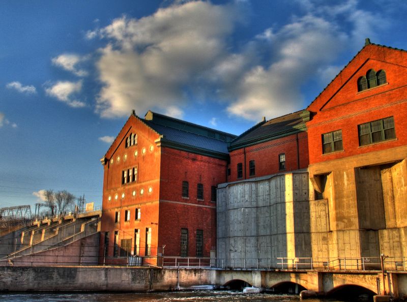
Combo of three handheld images. The left-hand side of this shows where the s/w couldn't match everything up quite right. I really have to remember to throw my tripod in the car! At least I don't forget the camera when I leave the house :)
From the historical marker: The Croton Hydroelectric Generating Dam began operation in 1907. It is capable of generating 8,800 kilowatts of electricity, enough to serve a community of about 4,900 people. The plant is located in Newaygo County’s Croton Township.

(by user:Lar)

Croton Dam is a dam and powerplant complex on the Muskegon River in Croton Township, Newaygo County, Michigan, operated by Consumers Energy. This composite was created from images taken from the downstream side, to the SE of the powerhouse. This image is near the E end of the dam, at location A on the locator, facing NW
تاريخ
سربس Croton Dam
چاگۊدنکس Brian from Michigan, USA ... uploaded by User:Lar
جواز
(هندئه کارأىتن اي فاىلˇ جي)
see cc-by-2.0 below
Map of area

جواز

w:fa:کرییتیو کامنز
تخصيص
این پرونده با اجازه‌نامهٔ کریتیو کامانز Attribution 2.0 عمومی منتشر شده است.
شۊمۊ تؤنين:
  • همرسؤني ئبه – برای کپی، توزیع و انتقال اثر
  • تلفيق گۊدن – برای انطباق اثر
تحت شرایط زیر:
  • تخصيص – شما باید اعتبار مربوطه را به دست آورید، پیوندی به مجوز ارائه دهید و نشان دهید که آیا تغییرات ایجاد شده‌اند یا خیر. شما ممکن است این کار را به هر روش منطقی انجام دهید، اما نه به هر شیوه‌ای که پیشنهاد می‌کند که مجوزدهنده از شما یا استفاده‌تان حمایت کند.
This image, originally posted to Flickr, was reviewed on Septemeber 9, 2007 by the administrator or reviewer Lar, who confirmed that it was available on Flickr under the stated license on that date.

عنوان

شرحی یک‌خطی از محتوای این فایل اضافه کنید

آیتم‌هایی که در این پرونده نمایش داده شده‌اند

توصیف‌ها فارسی

این خصوصیت مقداری دارد اما نامشخص است.

فلیکر فارسی

تاریخ انتشار فارسی: ۲۲ فئوريه 2006

43°26'14.100"N, 85°39'50.245"W

۲۱ فئوريه 2006

checksum انگلیسی

8ab160d951e025035e65a5f0234291852460a75c

۹۸٬۲۵۰ بایت

بلندی فارسی

۵۹۴ پیکسل

عرض فارسی

۸۰۰ پیکسل

فاىلˇ تاريخ

تاريخ/زمتؤنˇ سر کيليک بکۊنين تا اۊ تاريخ/زمتˇ نۊسخه' بىنين.

تاريخ/زمتکلˇ أنگۊشتيأبعادکارگيرنظر
ألؤنˇ نۊسخه‏۹ سپتامبر ۲۰۰۷، ساعت ۱۶:۳۰کلˇ أنگۊشتي عکس، ‏۹ سپتامبر ۲۰۰۷، ساعت ۱۶:۳۰ تاريخˇ نۊسخه' جي۸۰۰ در ۵۹۴ (۹۶ کیلوبایت)Lar{{Information |Description=(by Brian.H, from the Flickr page) Combo of three handheld images. The left-hand side of this shows where the s/w couldn't match everything up quite right. I really have to remember to throw my tripod in the car! At least I d

اي ولگ اي تاتاىئه خال بدأ دأنه:

فاىلˇ سراسري کارأىتن

اي ويکئن اي فاىله کارأىته دأنن:

گتˇ دىتا